アメリカ土木学会がミレニアム・プロジェクトと称して人類の大プロジェ クトを選定したことがある。ミレニアム=千年紀といいながら、同学会 はなぜか候補を20世紀のプロジェクトにしてしまった。そのミレニアム・プロジェクトで海運部門に選ばれたのがパナマ運河だったのは、それが20世紀に完 成した大プロジェクトだったからだろう。しかし、本来的名意味でこの部門のミレニアム・プロジェクトはスエズ運河だとぼくは思う。パナマ運河はスエズの成 功体験の上に成り立っているからだ。
When the American Society of Civil Engineers selected the Millennium Monument, they put the precondition for candidates to be projects completed in the 20th Century. In the category of water transportation, they chose the Panama Canal. Should they no put the precondition, they must have selected the Suez Canal, the success of which the Panama Canal was built.
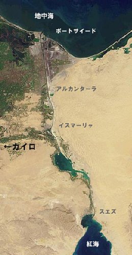
スエズ運河は地中海と紅海という二つの海を繋ぐ。逆の言い方をすれば、ユーラシア大陸とアフリカ大陸という二つの大陸を隔てるといってもいい。長さは 160キロあまり、エジプトのシナイ半島の付け根のあたりの砂漠を開削した運河だ。この運河によってヨーロッパからアジアへに向かう船舶はアフリカ大陸の 南端を大きく迂回する必要がなくなった。スエズ運河はいわば近道なのだが、スエズ運河を通ることによる航海短縮の距離は12,000キロにおよぶという。 節約される運行時間や燃料を考えれば近道を通らない法はない。
エジプトに滞在する日々、ある週末に思い立ってスエズ運河を見に行った。運河にはたどり着いたものの、なぜか大型の船影は見えない。2度目にスエズを見 に行ったときには、下調べをしてコンヴォイの通行時間を推測して臨んだ。しかし、現場では思ったように船団は来ない。もう来な いかと思った途端に、予想していたのと反対側から船団が来た。
こうして2回ほど、スエズ運河めぐりをすることになった。南の紅海側のスエズと北の地中海側のポート・サイド。途中にはイスマーリヤやアル・カンターラ といった町がある。高速バスやタクシー、セルビス(相乗りタクシー)などを乗り継いでスエズめぐりを楽しんだ。
The Suez Canal connects the Mediterranean Sea on the north and the Red Sea on the south. In other word, the canal separates the two continents, Eurasian and the African. With a length of about 160 km or so, the canal desects the desert at the foot of the Sinai Peninsula. This canal provides a short-cut route for the ships going from Europe to Asia and vice versa instead of a route going around the African continent. As the shrot-cut saves about 12,000 km of navigation, the Suez is in most cases unavoidable.
I set out to see the canal on one of the weekends there. I arrived at the canal bank but large ships are nowhere to be seen. I learned that a convoy was formed by ships navigating the canal, and in my second visit I came across with a convoy luckily. I visited the towns like Suez in the south, Port Said on the north, anand strolled about in small towns such as Ismalia and _Al Kantara in the middle.
写真をクリックすると大きな画像がみられます−
Please click on the photo to view a larger image.
Data <All images are degitized by Fuji Digital CD service.>
152-1 Suez, Egypt, February 2008/ Bessar R Ultron 28mm Kodak EB-3
152-2 Suez, Egypt, February 2008/ Bessar R Ultron 28mm Kodak EB-3
152-3 Suez, Egypt, February 2008/ Bessar R Ultron 28mm Kodak EB-3
152-4 Ismalia, Egypt, February 2008/ Bessar R Ultron 28mm Kodak EB-3
152-5 Ismalia, Egypt, February 2008/ Bessar R Ultron 28mm Kodak EB-3
152-6 Ismalia, Egypt, February 2008/ Bessar R Ultron 28mm Kodak EB-3
152-7 Al Kantara, Egypt, February 2008/ Bessar R Ultron 28mm Kodak EB-3
152-8 Al Kantara, Egypt, February 2008/ Bessar R Ultron 28mm Kodak EB-3
152-9 Al Kantara, Egypt, February 2008/ Bessar R Ultron 28mm Kodak EB-3
152-10 Port Said, Egypt, February 2008/ Bessar R Ultron 28mm Kodak EB-3
152-11 Port Said, Egypt, February 2008/ Hitachi Digital Camera HDC502
152-12 Port Said, Egypt, February 2008/ Hitachi Digital Camera HDC502